Presentation of the model
Writen by Hanieh Sayedhashemi in her PHD, readable here (Chapter 4, p85)
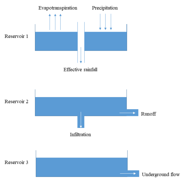
The EROS semi-distributed hydrological model simulates daily discharge (Thiéry, 1988; Thiéry and Moutzopoulos, 1995; Thiéry, 2018). This model is made up of a network of sub-basins in which each sub-basin is subjected to rainfall, snowfall and potential evapotranspiration. The water balance in the sub-basin is modeled by a lumped model using three reservoirs as follows:
the first reservoir represents the soil that is subjected to evapotranspiration and precipitation;
the second non-linear reservoir represents the vadose zone, models the percolation time, and determines the partition between runoff and infiltration;
the third reservoir represents the underlying aquifer characterized by a recession time, and characterizes the groundwater flow.
The contribution flow of each sub-basin is the sum of the runoff and the groundwater flow. The total flow at the outlet of each sub-basin is the sum of its contribution and the total flow of the upstream sub-basins (delayed by a transfer function representing their propagation time).
Water abstractions, dams and ponds are not considered in the EROS model, and the hydrometeorological balance in each sub-basin is carried out at a daily time step. This hydrological model was already used in several studies on the impacts of climate change (Ducharne et al., 2011; Moatar et al., 2013; Habets et al., 2013; Bustillo et al., 2014).
The EROS hydrological model uses Ta (°C), solid and liquid precipitation (mm), and reference evapotranspiration (ET0, mm) to produce daily Q and groundwater flows over the Loire River basin (Thiéry, 1988; Thiéry and Moutzopoulos, 1995). Meteorological inputs are provided by the SAFRAN atmospheric reanalysis data (Vidal et al., 2010). ET0 is computed from the SAFRAN variables with the Penman-Monteith equation (Allen et al., 1998).
Schematic figure of the EROS model operation for each sub-basin
Running T-NET with EROS data
Data requirement in the shapefile
Some columns are needed in the hydrographic network shapefile in
order to use correctly the TnetRUI package. A shapefile columns can be
check using the TNETutils_checkShapefile() function. For
J2000 hydrological modelisation, all needed columns are detailed in the
following table:
| Column name | Explanation | Fonction |
|---|---|---|
| OBJECTID_1 | ID of the segment | |
| ID_ND_INI | ID of the initial node | |
| ID_ND_FIN | ID of the final node | |
| ratio_left | Percentage of the left bank of the segment covered by vegetation (0 - 100) | |
| ratio_righ | Percentage of the right bank of the segment covered by vegetation (0 - 100) | |
| He_l | Mean height of the vegetation on the left bank | |
| He_r | Mean height of the vegetation on the right bank | |
| X1 | X coordinates of the segment (WGS84) | TNETshape_computePosition |
| Y1 | Y coordinates of the segment (WGS84) | TNETshape_computePosition |
| phi_deg | Orientation of the segment (angle with the north in degres) | TNETshape_computePosition |
| longueur | Length of the segments (in km) | st_length |
| id_M_New_1 | ID of the n°1 SAFRAN mesh crossed by the segment | TNETshape_getSafran |
| id_M_New_2 | ID of the n°2 SAFRAN mesh crossed by the segment | TNETshape_getSafran |
| id_M_New_3 | ID of the n°3 SAFRAN mesh crossed by the segment | TNETshape_getSafran |
| id_M_New_4 | ID of the n°4 SAFRAN mesh crossed by the segment | TNETshape_getSafran |
| id_M_New_5 | ID of the n°5 SAFRAN mesh crossed by the segment | TNETshape_getSafran |
| id_M_New_6 | ID of the n°6 SAFRAN mesh crossed by the segment | TNETshape_getSafran |
| id_M_New_7 | ID of the n°7 SAFRAN mesh crossed by the segment | TNETshape_getSafran |
| id_M_New_8 | ID of the n°8 SAFRAN mesh crossed by the segment | TNETshape_getSafran |
| Rap_new_1 | Aspect ratio of the segment in the n°1 SAFRAN mesh | TNETshape_getSafran |
| Rap_new_2 | Aspect ratio of the segment in the n°2 SAFRAN mesh | TNETshape_getSafran |
| Rap_new_3 | Aspect ratio of the segment in the n°3 SAFRAN mesh | TNETshape_getSafran |
| Rap_new_4 | Aspect ratio of the segment in the n°4 SAFRAN mesh | TNETshape_getSafran |
| Rap_new_5 | Aspect ratio of the segment in the n°5 SAFRAN mesh | TNETshape_getSafran |
| Rap_new_6 | Aspect ratio of the segment in the n°6 SAFRAN mesh | TNETshape_getSafran |
| Rap_new_7 | Aspect ratio of the segment in the n°7 SAFRAN mesh | TNETshape_getSafran |
| Rap_new_8 | Aspect ratio of the segment in the n°8 SAFRAN mesh | TNETshape_getSafran |
| LUpI | Total upstream network length at the initial node of the segment | TNETshape_computeUpstreamLength |
| LUpF | Total upstream network length at the final node of the segment (=LUpI + segment length) | TNETshape_computeUpstreamLength |
| air_strNFS | Part of the total drain area drain by the segment at the final node compared to the sub-watershed where it is (to dispatch discharge) | TNETshape_computeCoefQcalc |
| air_strNIS | Part of the total drain area drain by the segment at the ititial node compared to the sub-watershed where it is | TNETshape_computeCoefQcalc |
| air_unit | Part of the drain area drain by the segment compared to the sub-watershed where it is (to dispatch underground discharge) | TNETshape_computeCoefQcalc |
| nw_b | ||
| nw_f | ||
| L50_corr | ||
| H50_corr | ||
| Q50_corr | ||
| Bm | ||
| B_mes |
Functions arrangement
All function related to EROS hydrological function are regroup in the TnetEROS group. The functions are the following:
TnetEROS_readfiles()will read the output files from EROS computation. It’s used to read the discharge and groundwater flow and temperature files needed for the computation.TnetEROS_computeQ()will dispatch the discharge from EROS data on the TNET hydraugraphical network. The discharge is computed at the downstream of each T-NET hydraugraphical segments.TnetEROS_computeQamt()will dispatch the discharge from EROS data on the TNET hydraugraphical network. The discharge is computed at the upstream of each T-NET hydraugraphical segments.TnetEROS_computeQlatSout()will compute the underground lateral flow on all T-NET hydrographic segments.TnetEROS_computeTg()will distribute the underground temperature from EROS subwatershed to TNET segments.